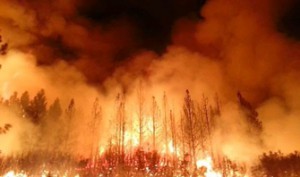
2014 is proving to be a historic year for wildfire activity in California and the Pacific Northwest. The National Fire Inter-Agency Center, in a report they update daily, put the combined number of fire-ravaged acres in California, Idaho, Oregon, and Washington, to date, at over half-million. Due to the prolonged drought in California, the number of wildfires in that state alone is 123% of the state’s average – and we’re only halfway into August.
With local firefighters working round the clock and, out-of-state teams journeying cross country to join them, one has to wonder if drones and IP camera systems might be able to play an assisting role.
Adding Drones to the Mix
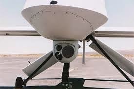
Last year, during the Rim Fire in California that destroyed 257,314 acres in Yosemite National Park and the surrounding Sierra Nevada Mountains, the National Guard launched a Predator Drone to aid firefighters by using infrared sensors to detect hot spots along the fire’s perimeters or in isolated spots.
The technology packed into the drone proved to be effective since it was able to use infra-red cameras to see through the smoke and dust to detect a spot-fire with the potential to spread to populated areas. Since it had technology to pick up the precise longitude and latitude it was able to pinpoint the coordinates so planes could be dispatched to drop water and fire-retardant chemicals over the site to keep it from spreading. The drone also made passes from one side of the fire to the other, using I-R to see through the smoke all the while detecting and keeping clear of two helicopters whose crew members were keeping an eye on the blaze from opposite sides.
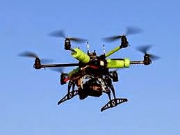
The Twin Falls Times-News reports that the Oregon Forestry Department is planning to equip a small remote control helicopter drone for the purpose of flying into smoky canyons where conditions would be hazardous to crews piloting helicopters. It could then share the data its infra-red camera footage and GPS systems gathered with fire crews on the ground. If it proves effective, they plan to equip firefighters with such small drones as regular equipment by 2016.
With an estimated cost of $5,000 and a gas tank that can keep it flying for 30 hours, the heli-drone would be a bargain compared to the $17m dollar Predator Drone that can stay aloft for 20 hours.
But First Some Questions
While drones are definitely an untapped resource in fighting the increasing numbers of wildfires, their use raises several doubts in firefighters’ minds.
First and foremost is the question of connectivity and second is also a question of…
Connectivity…
For a firefighter, viewing video and interpreting data supplied by a drone’s cameras and sensors is not the same as actually flying over the fire, hearing it, tasting it, seeing it and smelling it. This type of virtual intelligence is better than no intelligence at all but it’s not enriched by the intuition fire experts flying over the scene of the fire and connected to it by their senses depend on to predict what is apt to do.
and…….Connectivity
How will command centers on the ground connect with the drone pilot receiving the drone’s data first hand.
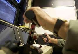
If they are located within an urban interface, connectivity to his iPad will be good, but out in the mountains and canyons where fires usually range? Lots of luck, Charlie.
The biggest concern of all is safety. Will the drones remain at their restricted altitudes or will they stray into the airspace of planes engaged in air attacks. As one official told the Times-News, “It’s bad enough to get hit by a bird. Think if you hit a 40-lb piece of metal…”
Kintronics is eagerly awaiting the day when technology for using IP camera systems in drones is developed, but at present only analog cameras are used in drones, with video encoders being used to enable network connectivity. Meanwhile, Kintronics has supplied cameras to The National Center for Landscape Fire Management, which is overseen and administered by the University of Montana College of Forestry and Conservation to be used in their remote sensing program, as well as to the Bridger-Teton National Forest.
Whatever your IP camera needs, call 914-944-3425 to speak to a sales engineer, or fill out an information request form.